Leonardo da Vinci’s map of Imola
 So what’s the big deal with an old map? Well, quite apart from the fact that I love maps anyway, this is a pretty special map.
While reading and enjoying Paul Strathern’s The Artist, The Philosopher and The Warrior (about the extraordinary confluence between around 1500 and 1504 of Da Vinci, Machiavelli and Cesare Borgia), I came across this fascinating section about Leonardo’s map making. Yet another facet of his genius. Centuries before manned flight was possible (despite the fact that it was something that obsessed Leonardo), here is a map so accurate that it could almost have been traced straight from Google Earth.
The confirming evidence placing Leonardo at Imola during this period [i.e. when Cesare Borgia was headquartered there] is a map that he made of the city. This is a work of astonishing technical achievement and precision; it is also a work of some beauty, which is heightened by the delicate wash colouring of the snaking blue course of the nearby River Santerno, the pale green of the surrounding fields and even the red clusters of houses within the city. Leonardo’s map depicts every street, every parcel of land and its buildings, main fortress and surrounding moat. These are all seen as if from the heavens, or a bird’s-eye view, just as we expect of a map today. At the time, this was something of an innovation. (p158)
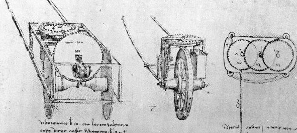
Distances were measured by simply pacing them out on the ground, or by the use of cords knotted at regular lengths, or with the aid of a hodometer, an instrument that measured distances by running a wheel across the ground. This hodometer was Leonardo’s own invention, and probably followed one of the three designs he drew in his notebooks during his period in Milan. The most advanced of these made use of a vertical rotating wheel set horizontally set above it (see below). (p160)
Medieval maps, with their drawings of mountains, castles and even fanciful animals such as dragons, possessed their own quaint but nonetheless recognisable aesthetic quality – a beauty which the more precise and practical early Renaissance maps frequently lacked. It may be that this copy of the original military map for Borgia was an attempt to explore how some element of that medieval aesthetic quality could be retained. As such, it certainly succeeds, in a way that many ensuing similarly precise maps do not. Precision quickly gave way to the formulaic; the reality of the terrain was adapted to the purpose of the map, rather than simply protrayed. Specific features – such as roads, towns, mountain contours, and so forth – were emphasised at the expense of a natural charm and beauty. Here too, though in a much more subtle way, it seems Leonardo was far ahead of his time. (p161)
Trackbacks & Pingbacks
- Leonardo’s Map of Imola | M E T A F O R M
- When a tomato is not just a tomato. | crazyholecook
- Leonardo’s map of the town of Imola, 1502. Surveyed by foot in combination with sighting from the tower at the town’s center, it was the most accurate map that had been made up to that point, and gives the appearance of a microorganism viewed
- This Old Map: Da Vinci’s City Plan, 1502 | MassCentral, Worcester
- This Old Map: Da Vinci’s City Plan, 1502 | | CityLab: Commit. Connect. Concern. Design. Develop. Deploy.


Though in fact (according to What The Romans Did for Us) the Romans were using this kind of hodometer (from Gk hodos meaning way, as in ex-hodos, way out) many years before…
i’m pretty sure that’s not in doubt – it’s merely the complexity of LdV’s invention drawn here…
Quaesitor, thanks for this, clever lad that Leonardo.
I ran into another telling of this story story last week in a John Pinto scholarly article about “ichnographic” city plans (http://www.jstor.org/stable/988969). learned about the article through something similar you’ll definitely enjoy – R. Burr Litchfield’s Florentine Gazetteer (http://cds.library.brown.edu/projects/florentine_gazetteer/).
The book you mention reminds me how much I enjoyed reading Dana Sobel’s Longitude back in the day, I’ll have to check it out!
Regards, Andrew Taylor